
In the world of aviation, navigating the skies has always been a complex and challenging task. Before the advent of GPS technology, aircraft relied on a system known as Inertial Navigation to guide them to their destinations. In this blog post, we will delve into the fascinating world of Inertial Navigation and how it played a crucial role in guiding aircraft before GPS became ubiquitous in the aviation industry.
Understanding the Basics of Inertial Navigation
Diving into the core of Inertial Navigation, it’s like unlocking a world where precision and smart calculations lead the way. This method, quite ingeniously, relies on a blend of accelerometers and gyroscopes. These devices are the unsung heroes in the background, meticulously recording every twist, turn, acceleration, and deceleration an aircraft experiences during flight. Imagine setting off on a journey without knowing your exact destination, but by keeping track of every move from the starting point, you could pinpoint your location at any given moment. That’s Inertial Navigation in a nutshell.
The accelerometers are tasked with monitoring the aircraft’s acceleration in any direction, whilst the gyroscopes keep an eye on its orientation by detecting changes in rotational attributes. By piecing together this information, the system calculates the aircraft’s velocity and direction, offering insights into its current position relative to where the journey began. It’s akin to setting off on a trek in the wilderness with a starting marker and meticulously noting every step forward, every turn, and every incline climbed, without the need for external references. This autonomous feature of Inertial Navigation is what makes it not just fascinating but also incredibly valuable in the realms of aviation and beyond.
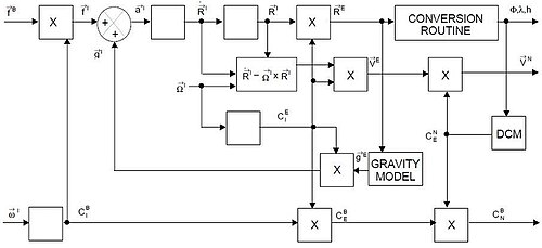
Image by Sherryl H. Stovall (Naval Air Warfare Center Weapons Division), Public domain, via Wikimedia Commons
The Evolution and History of Inertial Navigation Systems
The journey of Inertial Navigation Systems (INS) through history is a captivating tale of innovation and progress. It all began in the early 20th century when these systems were initially conceptualised for military applications, particularly in guiding long-range ballistic missiles to their targets with astounding precision. From these martial roots, the technology evolved rapidly, spurred on by the relentless quest for accuracy and reliability in navigation.
During World War II, the potential of inertial navigation was further realised as nations sought technological superiority. This period marked significant advancements, including the development of gyroscopes with enhanced stability and accelerometers capable of detecting even the minutest changes in speed. Post-war, the commercial aviation sector began to see the immense benefits of INS, leading to its adoption in civilian aircraft. This era saw engineers and scientists overcoming monumental challenges to increase the accuracy of inertial navigation systems and reduce their size, making them more practical for a wider range of applications.
The 1960s and 1970s were particularly revolutionary, as space exploration demanded navigation solutions that could function beyond the Earth’s atmosphere, where traditional methods like GPS were not feasible. This led to the refinement of INS technology, ensuring that spacecraft could embark on their celestial journeys with unparalleled navigational certainty.
Through decades of relentless innovation and refinement, inertial navigation has solidified its place as a cornerstone technology in the realm of navigation, demonstrating the incredible journey from its martial inception to a pivotal role in modern aviation and beyond.
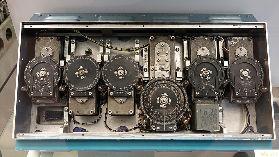
How Inertial Navigation Systems Were Implemented in Aircraft
Embarking on their integration into aircraft, inertial navigation systems found their place by being teamed up with other navigational aids. Initially, pilots would begin their journey by feeding the system their exact starting point. From then on, the system took over, employing its accelerometers and gyroscopes to diligently track the aircraft’s every move. This real-time tracking enabled the system to provide updates on the aircraft’s current location by calculating the distance and direction travelled from the starting point.
This collaborative approach to navigation, blending inertial systems with aids like radio beacons and even celestial navigation at times, provided a multi-layered navigational framework. This synergy allowed for a more robust way to guide aircraft, particularly during the early days when the technology was still finding its footing. Pilots could rely on these systems to maintain course, even in the absence of external reference points, making flights more reliable and paving the way for advancements in how aircraft traversed the skies. This ingenious implementation of inertial navigation marked a significant step forward in aviation, illustrating the technology’s versatility and adaptability.
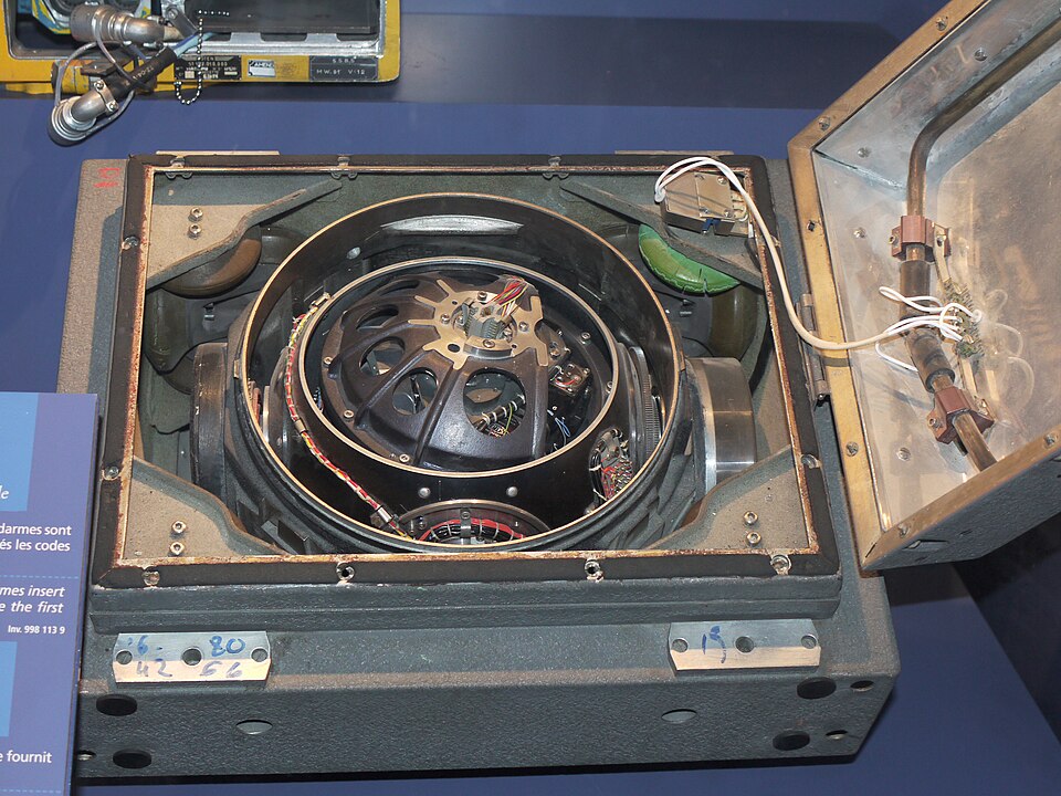
Image by Pline, licensed under CC BY-SA 3.0
The Limitations and Challenges of Early Inertial Navigation
While the advent of inertial navigation systems represented a quantum leap forward in the world of aviation navigation, it wasn’t without its share of teething problems. A primary hurdle that early adopters faced was the phenomenon known as “drift” – a gradual accumulation of navigational errors over time. This drift stemmed from slight inaccuracies in the system’s accelerometers and gyroscopes, which, while minor at the outset, could lead to significant deviations from the intended course over long distances. As a result, pilots and navigators had to perform periodic recalibrations, a process that required a keen understanding of the system’s workings and an acute awareness of the flight environment.
Furthermore, these early systems were bulky and demanded substantial space within the aircraft, posing a challenge in terms of weight and balance considerations. The complexity and cost of these systems also meant that their initial use was largely confined to military and high-end commercial aviation. Despite these hurdles, the pioneering spirit of aviators and engineers ensured that inertial navigation continued to evolve, paving the way for the highly sophisticated and reliable systems in use today.
Image by Auawise (derivative work: Jrvz), licensed under CC BY-SA 3.0, via Wikimedia Commons
The Transition from Inertial Navigation to GPS Technology
As the late 20th century unfolded, the aviation landscape witnessed a monumental shift with the introduction of GPS technology. This new method of navigation, utilising signals from satellites orbiting the Earth, offered unprecedented accuracy and reliability compared to traditional methods. Pilots were now empowered with real-time, pinpoint location information, making navigation safer and more efficient than ever before.
Despite GPS’s rise to prominence, the transition from inertial navigation was not abrupt. For a time, both systems coexisted, each complementing the other. Inertial Navigation Systems (INS) continued to provide valuable backup navigation capabilities, ensuring that aircraft could maintain their course even if GPS signals were momentarily lost or disrupted. This synergy between the old and the new enhanced the resilience of aviation navigation systems, offering layers of redundancy crucial for safe flying.
The role of Inertial Navigation in this era of transition cannot be understated. It highlighted the aviation industry’s adaptability and its relentless pursuit of technological advancements that enhance safety and reliability. As GPS began to take centre stage, the foundational principles of inertial navigation ensured that it remained a vital component of the aviation navigation ecosystem, demonstrating its enduring value in the face of emerging technologies.
Modern Applications of Inertial Navigation in Aviation
In today’s aviation landscape, the role of Inertial Navigation Systems (INS) extends far beyond their historical applications, embodying both resilience and adaptability. Whilst GPS technology has revolutionised how aircraft navigate, INS maintains its indispensable position, particularly as a fail-safe mechanism. In scenarios where GPS signals may falter – whether due to technical glitches or environmental factors – inertial navigation steps in to ensure continuous, uninterrupted guidance. This dual-system approach significantly enhances the reliability of aircraft operations, offering pilots and passengers alike peace of mind during their aerial journeys.
Moreover, the realm of unmanned aviation – including drones and UAVs (Unmanned Aerial Vehicles) – benefits immensely from INS. These crafts, often operating in complex or signal-compromised environments, rely on inertial navigation for accurate positioning and orientation, crucial for both routine missions and critical operations. The utility of INS in such applications underscores its versatility and ongoing relevance in an era dominated by satellite navigation.
Additionally, the burgeoning sector of space exploration continues to leverage inertial navigation for spacecraft and satellites, where traditional GPS is not a viable option. This underlines the technology’s critical role in guiding humanity’s quest beyond the Earth’s confines, further solidifying its significance in both contemporary and future aviation endeavours.
Future Prospects of Inertial Navigation Technology
The horizon for inertial navigation systems (INS) beams with potential, fuelled by relentless innovation and a drive towards perfection. As we stride further into the future, these systems are set to become even more precise, more dependable, and astonishingly compact. The evolution of INS promises to usher in a new era of aviation navigation, where navigating the vast skies becomes even more seamless and foolproof.
Emerging technologies and cutting-edge research are at the heart of this evolution, pointing towards systems that can self-correct in real-time, reducing the historic challenge of drift and enhancing overall navigational accuracy. Imagine aircraft equipped with INS that are not only lighter but also smarter, capable of adapting to changes in their environment instantaneously and with unparalleled precision.
Moreover, the integration of artificial intelligence and machine learning into inertial navigation heralds a future where these systems can learn from past voyages, continuously improving their accuracy and efficiency. This adaptability could redefine the parameters of autonomous flight, making unmanned missions more reliable and safer than ever before.As we look to the future, the ongoing refinement of inertial navigation technology stands as a testament to human ingenuity and our unyielding pursuit of excellence in aviation. It’s an exciting journey ahead, and the possibilities are as boundless as the skies themselves.


